
Post-meeting tour
Visit to LTER site – Mondego Estuary
The Mondego River drains a catchment area of approximately 6670 Km2 and its valley, which is very steep in upstream sections, forms a large alluvial plain consisting of good agricultural land downstream from Coimbra.
Since the 1960s, the Mondego catchment area underwent a large scale morphological modification, involving the construction of stone walls and small water reservoirs, to regulate the river water flow and enlarge the harbour facilities. The aim was to control floods, improve the uses of water resources, namely regarding populations, industries, and agriculture, and produce electric power. The works continued during the 1970s and the 1980s, although the original plan was only partially accomplished. Nevertheless, interventions caused a strong anthropogenic impact in to the system, modifying the riverbed topography and changing the system hydrodynamics.
The entire catchment area drainage contributes presently with a high anthropogenic loading of nutrients and several chemicals into the Mondego estuary (Western coast of Portugal - North Atlantic Ocean Eco-region), which as many other coastal and marine water bodies have experienced what may be named as cultural eutrophication. Besides, the estuary supports industrial activities, salt-works, and aquaculture farms, and is location of Figueira da Foz, a harbour and a centre of seasonal touristic activity.
The Mondego estuary is a relatively small (1600 ha) warm-temperate polyhaline intertidal system, which receives the agricultural runoff from 15 000 ha of upstream cultivated land (mainly rice fields). Its terminal part is 7 km long and is 2-3 km across at its widest part, consisting of two arms, north and south, separated by the Murraceira Island.
The two arms of the estuary have very different hydrographic characteristics. The north arm is deeper (5-10 m during high tide, tidal range 0.5-3.5 m), constituting the main navigation channel and the location of the harbour. The south arm is shallower (2-4 m during high tide), and is characterised by large areas of intertidal flats exposed during low tide.
In the early 1990s the south arm was rather silted up in the upstream areas, which caused the Mondego outflow to run essentially through the north arm. The water circulation in the south arm was mostly due to tides and to the relatively small fresh water input of a tributary, the Pranto River, which was artificially controlled by a sluice, located at 3 km from the confluence with the south arm of the estuary. In addition, due to differences in depth, the penetration of the tide was faster in the north arm, causing daily changes in salinity to be much stronger, whereas daily temperature changes were higher in the south arm.
Measures involving an ample re-establishment of the communication between the two estuarine channels were proposed and subsequently applied. Such intervention, as a matter of fact fully compliant with the new European Marine Strategy, was undertaken during the spring of 2006 and concluded the 6 of May. This created a rare opportunity of obtaining inestimable new knowledge, both theoretical and empirical, by investigating the system’s response through a comprehensive comparison of the former and present situations, taking into account the most relevant ecological quality elements.
Visit Program (22 nd September)
8:30 – Departure from Lisbon
10:45 – Arrival to Montemor-o-velho Castle to observe the all the low Mondego view.
11:30 – Stop at Ereira Bridge considered the connection area between the river and the Mondego Estuary.
12:00 – Lunch at Figueira da Foz in a typical fish restaurant.
13:45 – Visit to the Low Estuary with stops at:
- North arm
- Monitoring Station
- South arm
- Salt eco-museum
- Alvo sluice (Pranto)
17:30 – Departure to Lisbon
19:30 – Arrival to Lisbon
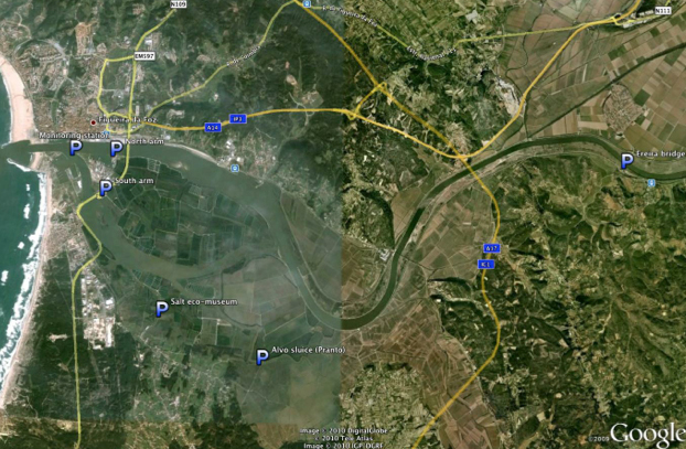
Map of the Lower Mondego river and estuary
sponsors